Pacific Coast
Big trees, big waves, beautiful beaches.
Along the Pacific Coast Route, you’ll get to see marine wildlife such as sea lions, and as you pass you can hear them barking. Take the time to watch as one by one they dive off their rocks in search of their daily meal of fish from the ocean. During the peak tourist season, there is heavy recreational vehicle traffic along U.S. Highway 101 and State Highway 1 along the coast, so cyclists must ride cautiously and defensively.
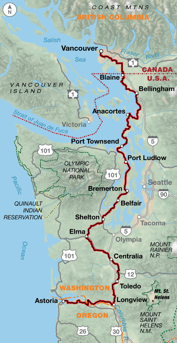
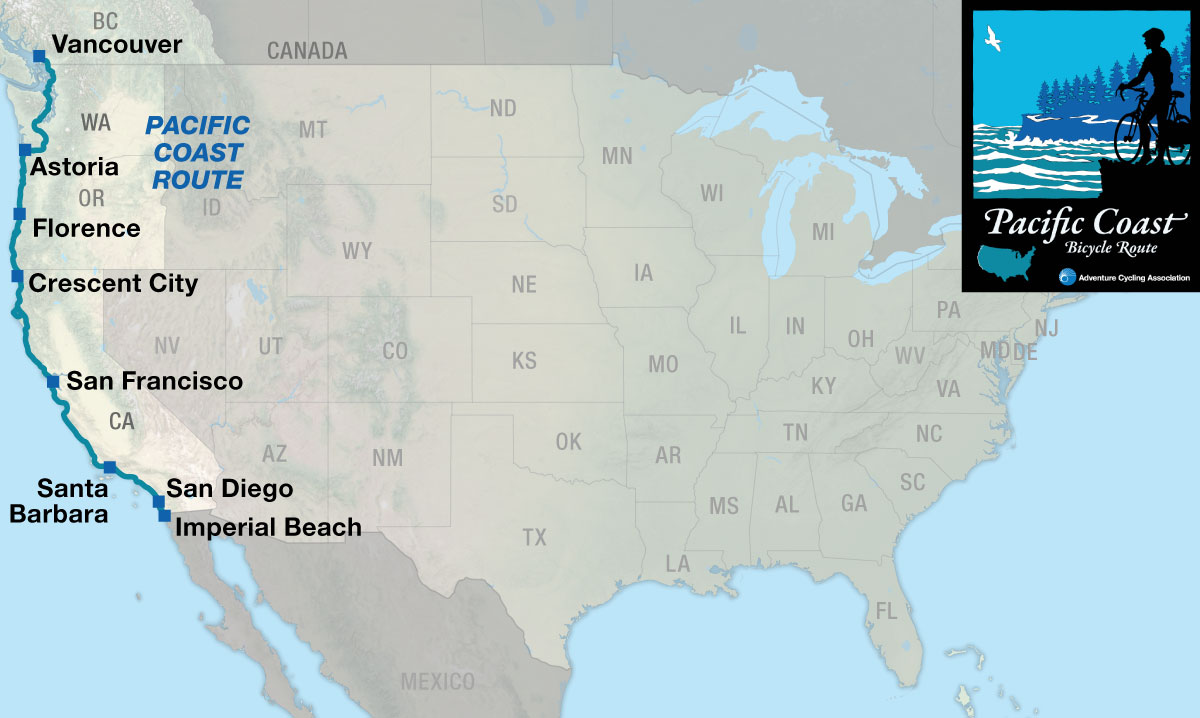
The route begins in Vancouver, British Columbia and heads south through the suburbs of this large city. Farmlands appear before crossing the border at Blaine into the United States, and you’ll continue through more rural countryside in Washington. After crossing Deception Pass, the route is on Whidbey Island, where there is a large U.S. Naval Reservation, and the loud noise of test jets flying overhead can be heard. There’s a ferry ride over to Port Townsend, which is back on the mainland. The route then winds southward through a series of small towns on the eastern side of the Olympic Peninsula. In Bremerton, if you’re interested, you can take a ferry to downtown Seattle and its attractions. You’ll then head into logging country and see forest plantations in various stages of development: recently clear-cut, newly planted, middle-aged, or ready to be harvested. At Castle Rock, a five-mile side trip leads to the Mount St. Helens Visitor Center, which tells the tale of the volcano’s eruption in 1980.
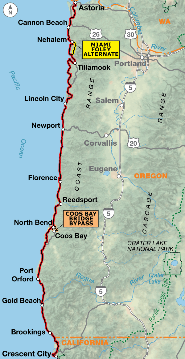
A short ferry ride crosses the Columbia River into Oregon. Leaving Astoria, you’ll begin a magnificent ride down the coast. The route stays along the shoreline and headlands, passing mile after mile of spectacular scenery including lighthouses, craggy coastal pines, and rock formations in the water. Innumerable parks dot the coast and invite one to stop, and take hikes down to the water for tide pool viewing. Small towns are abundant and cater to the tourists who invade the coast from spring to fall.
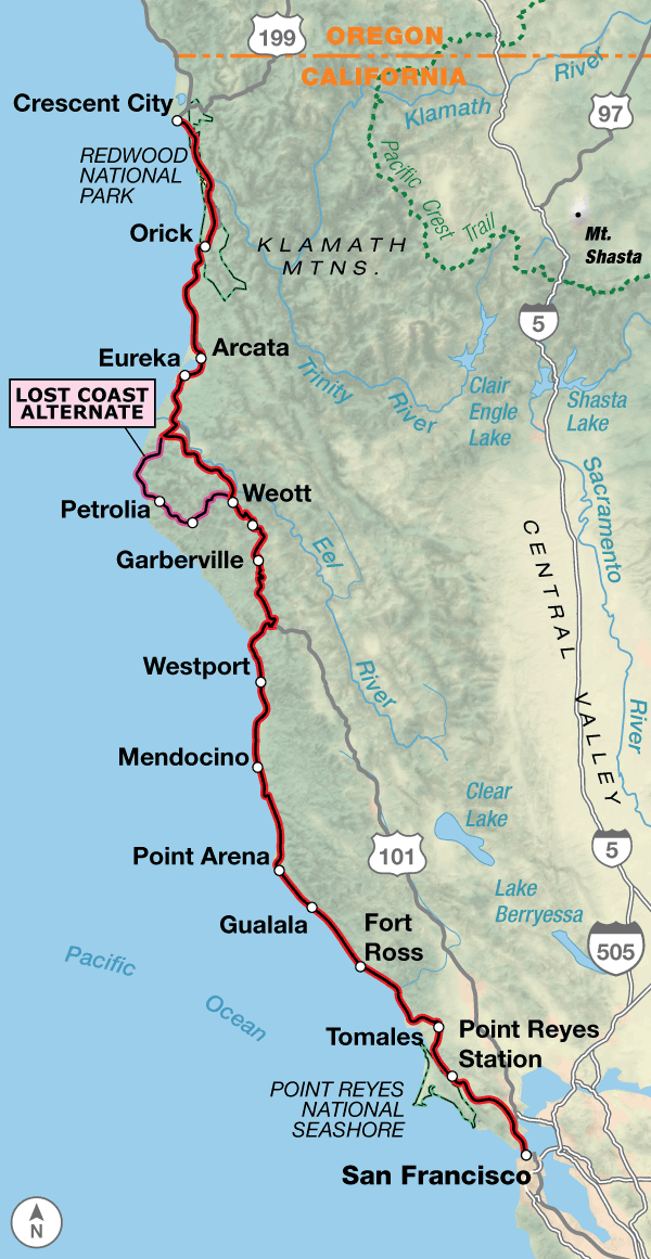
The California coast is tremendously diverse. You’ll encounter massive redwoods, breathtaking coastline vistas, acres and acres of vegetable farms, fruit orchards, and many busy urban areas.
The curvy, winding roads along the coast are shared with cars, recreational vehicles, farm trucks, and logging trucks, so extra caution is needed by cyclists. There are bike paths in some of the large cities the route goes through, and you’ll need all your defensive urban cycling skills to contend with the heavy traffic. But this is California, land of sun and fun (especially along the southern portion of the route). Take advantage and go jump into the Pacific on a whim or watch a beautiful sunset.
Soon after passing through Crescent City, you will be biking through awe-inspiring redwood country on roads shaded by trees reaching high into the sky. A herd of elk live near Orick and are usually easy to spot. The redwoods are a big tourist area, so you’ll have the opportunity to bike through trees that most people drive their cars through. After leaving the redwoods, you’ll enjoy scenic riding along the Pacific Ocean, where the route climbs and descends along the coastal headlands.
Biking over the Golden Gate Bridge into San Francisco is a real treat, and the route stays on the western edge of the city. Heading southward along the coast, there are numerous state beaches. If you’re at the Año Nuevo State Reserve during the elephant seal mating season in January, viewing the seals is not to be missed. North of Monterey, acres of farms begin to appear in the Salinas Valley, a prime agricultural area known as the “Salad Bowl of the World.”
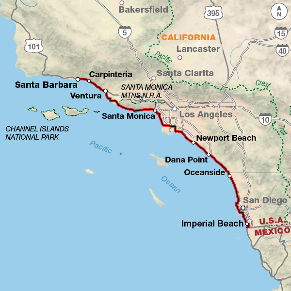
After leaving Carmel, the ride south on the Pacific Coast Highway along the Big Sur Coast is the most spectacular portion of the route for many cyclists. This winding, scenic road high above the ocean has been seen many times in television shows, commercials, and movies. Leaving the Santa Lucia Mountains and the coast, it is evident that you’ve reached “southern” California. You’ll encounter many fertile farms and areas with various degrees of development. Santa Barbara is an easy town to cycle through. When you reach Malibu, you’ll find tremendous congestion and view hundreds of trophy homes built into the hillsides or along the beaches. This is the northern end of the Los Angeles megalopolis.
Beginning in Santa Monica, the route uses some beautiful bike paths that go right through the middle of the sandy beaches, and then you’ll ride through residential and industrial areas before rejoining the Pacific Coast Highway south of the city. All the way to San Diego, there will be a mix of urban cycling through towns, bike paths, highways, and shore roads. Through San Diego and its suburbs, the route follows residential streets and bike paths to the Coronado Pedestrian-Bicycle Ferry, which takes you to Coronado and a bike path along Silver Strand State Beach, then to the route’s end at Border Field State Park next to the Mexican border.
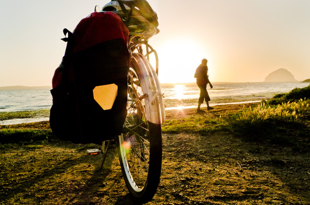
Photo by Russ Roca
The route’s terrain in Canada and Washington is flat to rolling hills, with a few climbs. Biking along the Oregon coast means hills, and some of them are steep, but it also means that your spectacular views will be well-earned. Don’t forget that your uphills on one side of a coastal headland mean a downhill on the other side.
Northern California is generally hilly, with lots of ups and downs following the coastline. There is a large climb/descent between Leggett and the coastal highway on section 3. The route remains hilly until Santa Barbara. Some sections in the southern part of the route are rolling to flat, especially along the various cities’ bike paths along the beaches.
| Pacific Coast - Main Route | ||||
|---|---|---|---|---|
| Section | Distance | Elevation | Total Climb | Avg. Climb/mile |
| Total | 1,862.6 miles | Minimum: 0 ft.Maximum:1,910 ft. | 106,520 ft. south bound106,045 ft. north bound | 57 ft. per mi. south bound57 ft. per mi. north bound |
| 1 | 413.5 miles | Minimum: 0 ft.Maximum:660 ft. | 18,715 ft. south bound18,950 ft. north bound | 45 ft. per mi. south bound46 ft. per mi. north bound |
| 2 | 407.7 miles | Minimum: 0 ft.Maximum:840 ft. | 22,840 ft. south bound22,620 ft. north bound | 56 ft. per mi. south bound55 ft. per mi. north bound |
| 3 | 407.8 miles | Minimum: 0 ft.Maximum:1,910 ft. | 30,545 ft. south bound29,830 ft. north bound | 75 ft. per mi. south bound73 ft. per mi. north bound |
| 4 | 383.1 miles | Minimum: 0 ft.Maximum:1,135 ft. | 26,935 ft. south bound27,105 ft. north bound | 70 ft. per mi. south bound71 ft. per mi. north bound |
| 5 | 250.5 miles | Minimum: 0 ft.Maximum:445 ft. | 7,482 ft. south bound7,540 ft. north bound | 30 ft. per mi. south bound30 ft. per mi. north bound |
| Pacific Coast Alternates | ||||
|---|---|---|---|---|
| Name | Section | Distance | Total Climb | Avg. Climb/mi |
| Seattle Ferry Spur | 1 | 1.4 miles | 150 ft. east bound175 ft. west bound | 107 ft. per mi. east bound125 ft. per mi. west bound |
| Coos Bay Bridge Bypass | 2 | 16.9 miles | 960 ft. south bound1,015 ft. north bound | 57 ft. per mi. south bound60 ft. per mi. north bound |
| Miami Foley Alternate | 2 | 14 miles | 470 ft. south bound450 ft. north bound | 34 ft. per mi. south bound32 ft. per mi. north bound |
| Lost Coast Alternate | 3 | 65.5 miles | 8,190 ft. south bound8,075 ft. north bound | 125 ft. per mi. south bound123 ft. per mi. north bound |
| 17-Mile Drive Alternate | 4 | 11.6 miles | 1,105 ft. south bound565 ft. north bound | 76 ft. per mi. south bound39 ft. per mi. north bound |
This route can be ridden at any time of the year, but spring and autumn are optimal periods to avoid the heavy tourist traffic in the summer. And be forewarned: winter rains can cause flooding and mud slides and may close roads, especially along the northern California coast. Dense fog can also be a problem during any season. Washington and Oregon normally have dry sunny weather in August and September while the spring season is usually rainy. Due to changing local conditions, it is difficult to predict any major wind patterns, but during summer, strong winds will prevail from north to south.
There are plenty of services along the route. The Oregon coast draws a large amount of tourists, so it has the facilities to cater to them. For those who are camping, there are many state park campgrounds near the beaches with hiker/biker sites.
In California, there is a stretch between Half Moon Bay and Davenport south of San Francisco that doesn’t have much to offer, so plan ahead with extra drinks and snacks. The northern and southern coasts are high-profile tourist areas, so facilities are numerous, but be prepared for higher prices. For those who like to camp, there are many appealing campgrounds at state parks near the beaches, perfect for watching dramatic sunsets. The 60 miles south of Big Sur have very limited services.
Some campgrounds will charge a cyclist traveling alone less if they have hiker/biker sites, but often they will charge the price of a regular tent or RV site, and that can easily be $20-$50/night (higher in tourist areas). The maps list churches that have opened their doors to cyclists, but they aren’t all that closely spaced. If you’re friendly and ask around, you can often get yourself invited to camp in a yard. Our routes sometimes go through national forests (moreso in the west) and you are allowed to camp anywhere on national forest land as long as you “pack it in, pack it out.”
You may also wish to sign up with Warmshowers, a reciprocal hospitality site for bicycle travelers, for other overnight options.
Public Transit Option to the US-Mexico Border at San Ysidro
You can ride on the mapped route to the Broadway Ferry Pier on the San Diego waterfront, and then ride off route 2 blocks east on Broadway to the America Plaza light rail station, where you will get on the southbound Blue Line light-rail train (although it’s referred to locally as a “trolley”).
You may take your bike aboard the San Diego Trolley at any time, even during rush hour — but there are limits. During rush hours (6-9 AM and 3-6 PM on weekdays) only one bicycle is allowed on each trolley car. At other times, two bicycles are allowed on each trolley car. Buy a regular trolley ticket or pass.
From downtown San Diego, a trip to the Mexican border will take about 45 minutes on the Imperial Way blue line. To get to the San Ysidro border station, you will need to get on the blue line at any station going south toward San Ysidro. You will take the line all the way to the end and get off at San Ysidro.
Route Highlights
Pacific Coast Highlights
- Vancouver, British Columbia, Section 1
- Deception Pass State Park, Section 1
- Mount St. Helens Visitor Center, Section 1
- Tillamook Cheese Factory, Section 2
- Oregon Dunes National Recreation Area, Section 2
- Samuel H. Boardman State Scenic Corridor, Section 2
- Redwood National Park, Section 3
- The Lost Coast, Lost Coast Alternate, Section 3
- Humboldt Redwoods State Park, Section 3
- Point Reyes National Seashore, Section 3
- Golden Gate National Recreation Area, Section 3
- San Francisco, California, Section 4
- Golden Gate Park, Section 4
- Monterey, California, Section 4
- Big Sur Coast, Section 4
- California Sea Otter Game Refuge, Section 4
- Santa Barbara, California, Section 4
- Los Angeles, California, Section 5
- San Diego, California, Section 5
More Route Resources
- U.S./Canada Visa Information
- Translink, biking and transit in Vancouver (British Columbia)
- City of Vancouver Cycling Map (British Columbia)
- Vancouver area Cycling Map (British Columbia)
- How To Travel With Your Bike on Amtrak
- U.S. Bicycle Route System
- U.S. Bicycle Routes in Washington (Washington)
- No-Turn-Away Bike Camping Policies (Washington)
- South Bay Trail, Bellingham (Washington)
- Interurban Trail, Bellingham (Washington)
- Washington State Ferry System
- Larry Scott Trail, Port Townsend (Washington)
- Seattle Bicycling Guide Map (Washington)
- Wahkiakum County Ferry (Washington)
- Oregon Coast Bike Route
- Tillamook County Transportation District bus between Portland and the coast (Oregon)
- Coquille Indian Tribe (Oregon)
- U.S. Bicycle Routes in California (California)
- Caltrans State Highway Conditions (California)
- California bike maps
- Tolowa Dee-ni’ Nation (Smith River Rancheria, California)
- Hammond Trail, McKinleyville (Northern California)
- Humboldt Bay Trail, Arcata (Northern California)
- Eureka Waterfront Trail (Northern California)
- Hikshari’ Trail, Eureka (Northern California)
- Caltrans District 5 Central Bike Map (Central California)
- Marin County Bicycle Map (California)
- Cross Marin Trail (California)
- Mill Valley Sausalito Bike Path (California)
- Golden Gate Bridge (California)
- San Francisco Airport bicycle assembly stations (California)
- San Francisco Bay Trail Maps (California)
- Marin Bike Map (California)
- San Francisco Bay Ferry (California)
- Devil’s Slide Coastal Trail (California)
- Santa Cruz County Bikeways Map (California)
- Monterey County Bike Map (California)
- San Luis Obispo County Bike Maps (California)
- Santa Barbara County Bike Maps (California)
- Los Angeles County Bike Maps (California)
- Visit Oceanside Conference and Visitors Bureau (California)
- San Diego Regional Bike Maps (California)
- Border Field State Park (California)
- Connect and share photos with other riders on Instagram: #acaPacCoast
Updates to Recently Released Maps
If you are planning a bike tour, be sure to get the most recent map updates and corrections for your route by selecting the route, and the appropriate section(s), from the drop-down menu below.
Over time maps become less useful because things change. Every year Adventure Cycling’s Routes and Mapping Department create map updates and corrections for every map in the Adventure Cycling Route Network, which now totals 52,047 miles. With the help of touring cyclists like you, we receive updates on routing, services, camping, and contact information. Until we can reprint the map with the new information, we verify the suggested changes and publish corrections and updates here on our website.
PLEASE NOTE: Covid has been particularly hard on the small businesses along our routes. While we do our best to keep the maps and these online updates current, you may encounter more closed businesses and longer stretches with limited or no services.
Refer to these updates for the most current information we have and submit reports of changes to the Route Feedback Form for the cyclists coming after you.
NOTE: Map updates and corrections only pertain to long term changes and updates. For short term road closures, please see the Adventure Cycling’s Routes Temporary Road Closures discussion in our Forums.
